AFRICAN ENCOUNTER
Overland Safari Blog
January – May 1973
Part Five – From Kigali (Rwanda) to Eastern Zaire
via King Edward National Park


22 March 1973 That border crossing that eventually brought us to Zaire, was our first real encounter with the mysterous heart of Africa which I had heard about in childhood, and was probably one of the main reasons for taking part in this journey.
Although we had the necessary visas for entry to the country we were required to have our currency recorded. I suspect that, since Uganda had been regarded unsafe for tourists and travellers, that the border guards had become used to seeing groups travelling in either direction and taken a fairly relaxed approach to them.
However, we regarded that border post with some foreboding, as a mistake, or wrong word, could have ended the chance of completing the trip for one, or all, of us. We had to demonstrate to one of the guards at the border that we had sufficient cash to spend $50 (I think) a day whilst we were in the country – a journey which would take some 10+ days. The guard demanded to see each of us individually and to show him the necessary cash which he duly recorded on a form which he stuck inside our Passports. He may, or may not have known, that we certainly did not have the necessary ready cash and that what was presented to him by each of us travellers was, more or less, the same wad of notes that he had seen from the previous person. Also, when he had seen about half out us, it was really little surprise,he found that he had no more forms, and was obliged to forget the whole exercise and allowed us to proceed. It was therefore with some considerable relief that we left the border post and quietly indulged in some muffled celebrations.
Having arrived in Zaire and seen Lake
Kivu our next challenge was going to be to climb Mount Nyiragongo, which is an
active volcano. We obtained the services of a guide, but were soon spread out
along the path which led up the mountain. Eventually darkness fell before we
had reached the top with those at the back protesting strongly that “they had
paid for the guide as well! 9I was probably the most vocal! There was great relief when we eventually arrived
at the Tourist hut near to the top of the mountain / volcano. From there we
were able to walk in the dark, and with the greatest care, look over into the
active volcano, and to spend the night in the hut.

Lake Kivu

A surprisingly attractive corner just inside Zaire – which looked as if it had been cultivated by the Belgians who had lived there until relatively recently.

Welcome to Vulcan Nyiragongo

The view going up the mountain
Between 1894 and 1977 the crater of
Nyiragongo contained an active lava lake. On 10 January 1977, the crater walls
fractured, and the lava lake drained in less than an hour. The lava flowed down
the flanks of the volcano at speeds of up to 60 kilometres per hour
(37 mph) on the upper slopes, the fastest lava flow recorded to date, overwhelming
villages and killing at least 70 people. Within 30 minutes, the lava lake
had emptied, flowing north, south, and west of the volcano. Nowhere else in the
world does such a steep-sided stratovolcano contain a
lake of such fluid lava. (Wikipedia) Nyiragongo’s proximity to heavily
populated areas increased its potential for causing a natural disaster. The 1977 eruption
raised awareness of the unique dangers posed by Nyiragongo, and because of
this, in 1991 it was designated a Decade Volcano, worthy of
particular study. (Wikipedia)

Mount Nyiragongo from near Goma
The following morning when we set out
to return to our base at the bottom of the mountain, I was striding out on my
own, probably rather unwisely, and eventually running to get back to where the
truck was parked; I was well aware that there were elephants and buffalo and
probably other animals in the vicinity, which I did not want to meet face to
face, I recall the sounds of the birds as I sped down the mountain, but not being
quite sure of what it was that I was hearing.
23 March 1973 Having
re-assembled the Group near Kivu we headed north into Eastern Zaire – (this was
an area which in future years would become over-run by refugees from the
conflicts and genocide in Rwanda and elsewhere, and had, in the past suffered
from the conflicts following the granting of independence from Belgium).
We would see plenty of evidence of
time of the Belgians, there were some very nice houses apparently in the middle
of nowhere, presumably all had possesed mod-conveniences, but were now simply shells,
unlived in and unloved while the native Congolese had gone back to living in their
basic dwellings made of wood and leaves etc, with occasionally a corrugated tin
roof.
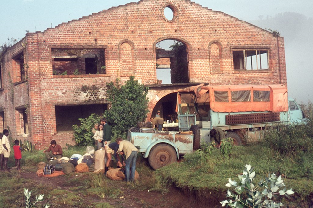
The remains of what would have been the substantial house of a Belgian Congolese family house which served us as a residence for
one night

Our “audience” for this part of the encounter, looking just little self conscious about our presence, but nonetheless very interested.
Zaire was now ruled by a former
soldier who had become President Mobutu. I had with me a cassette recorder from
which I used to listen to the few tapes of “proper” music that I had brought
with me. It was at this stage of the journey that the cassette recorder started
to be used for another purpose. Whenever we stopped a crowd would usually
gather simply to watch these strange folk who had appeared from nowhere, and
seemed to be going to.....no-where. Most of the crowd were children and I
encouraged them to sing, and to record them; they absolutely loved listening to
the sound of their own voices. I had hoped that they might sing some of the
more traditional Congolese music, but what they sang was what I imagine they
had been taught in school, Church or where ? – this included the Zairean National Anthem and songs
in praise of Mobutu – how well they had been conditioned by the dictator and
his cronies.
24 March 1973
We entered Zaire’s Albert National
Park, named after a Belgian King, and drove alongside the river for several
miles until it became to late to travel further and we had to pitch camp. The chosen spot was adjacent to the
river which was home to a number of Hippos who remained in the River, and who caused us some amusement with
their grunting. We set up our tents at a point where it was dry, but om reflection, looked as if, it was used by the Hippos as their wallowing place. We were advised to set our
tents sufficiently far apart so that if the hippos did come out of the River during the night, they would not be panicked by tripping over the guy
ropes. Fortunately they did not venture out of the river during the night but
the sound of their grunting was enough to ensure that our sleep was anything
but silent. ( I suspect that none of us realised exactly what damage a full-grown Hippo could cause to a human - or we might have chosed to camp elsewhere!)

It was usually a question of had we come to see the animals or had they
come see us? For once animals we saw were face-on rather than their rear-ends as they retreated from us - Zairean (Congolese) Buffalo

The Hippos in whose “wallow” we camped
We also encountered Elephant and
Buffalo whilst in the park but fortunately they did not seem to mind our
presence – remembering that tourists and travellers would have been relatively
infrequent in this part.
The next night night we came across a deserted settlement,
and, as it looked as if it was going to rain, we thought about settling in some
of the deserted houses. Our leader explained that such settlements were usually
deserted for one or two reasons – either the occupants had just left, or
alternatively, and worryingly, they had been smitten with some disease which
had wiped-out the population.
A search was started for a local
person who could speak French or English. Enquiries were made amongst what
local people could be found and it was confirmed that the village had not been
deserted because of disease, rather that the populace had left to go
elsewhere. Given the issues which had necessitated us travelling by this
route, namely the ruler of Uganda – Idi Amin and his high unpredictable behaviour, we
thought that such population movements occurring in relatively close proximity
to the border with Uganda were quite possible.
25 March 1973
The next day brought some new
experiences. First, we had our first encounter with a tribe of Pygmees who
lived close to the road that we were following.


A slightly clearer shot of a Pygmee dwelling
On another day we encountered other
Pygmee settlements and they were not welcoming to our presence and having
Cameras pointed in their direction. I suspect that they may well have had
reasons for disliking white people and had suffered at their hands in the past,
and regarded us as a threat. Given that we were aware of the fact that Pygmee
tribes could be well armed with poisoned weapons we did not linger too long to
try and make their acquaintance.

Having left the Pygmees behind our
next encounter was with the sign which told us that we were crossing the
Equator, this was a great surprise, coming as it did in the “middle of
nowhere”. We duly piled out of the truck and lifting the sign from out of the
ground to sit amongst us as we posed for our photos, before returning the sign
to its rightful place for future travellers. (I have included this photo on the
title page).
That night we camped at Emingeti, on
the local soccer field, where I was able to make my first recording of the
local boys singing the Zairean national anthem and other things.
26 March 1973
As we drove north on the next day it
became more obvious that we were going somewhere important as we passed more
and more people, mostly woman with loads on their head including such things as
vegetables and clothes. Eventually we arrived at the centre of the activity, a
marketplace where produce was being brought from north and south. As well as
items for sale there were children being carried in the usual African way in a
papoose made from a large shawl. At the entrance to the market was a “crèche”
where babies and small children had been left in the care of a minder, whilst
their mothers went off in search of purchases. The market was one of the most
vibrant scenes we had seen in Africa and the sounds of its business could be
heard for some distance away. As we left new sellers and buyers continued to
arrive at what was clearly one of the most important centres of commerce for
many miles around.


Different types of “child minding” at the market

Staying with Mother and a bunch of bananas which appear to be growing out of the Child's head.
That night we spent camped in what
had become a road repair depot, there were a number of them along the road, not
much used to judge by the state of the road, but great places in which to set
up camp for the night.
Whilst in Johannesburg I had been
taking singing lessons and my teacher had recorded some song accompaniments and
exercises for me to work with. I used the recordings on our trip, usually out of
hearing of the rest of the group. This night when we camped in a road-mending
area, I went out into the dark, with a torch, by the “main road” and had a
good bellow at my vocal exercises. A small group of Congolese were walking home
along the road with no light to help, and I don’t know who was the more
surprised. I do feel sure that they had never come across a (mad) white man
standing by the road in the dark singing his head off. We managed to have
something of a conversation in a mix of languages before they continued on their way home in the
dark.
The Next Instalment will include: the rarely seen Okapi, The Zaire River and Kisangani (previously Stanleyville) and, inevitably, its Railway.

This map can help in tracing some of our route - From Mbeya in Tanzania up to Moshi and Kilimanjaro then Nairobi, Mombasa, Kigali in Rwanda then north and west to Kisangani in Zaire


Comments
Post a Comment